From: "ARRL Web site" <memberlist@www.arrl.org>
Date: Apr 16, 2015 8:18 PM
Subject: The ARRL Letter for April 16, 2015
To: <guyperea1@gmail.com>
Cc:
If you are having trouble reading this message, you can see the original at:
April 16, 2015 Editor: Rick Lindquist, WW1ME
| ||||||||||
ARRL, US House Members Coming Through to Support H.R. 1301 Many ARRL members have answered the call to urge their US House member to co-sponsor The Amateur Radio Parity Act of 2015 -- H.R. 1301 -- helping to raise the list of co-sponsors to 39. But ARRL Regulatory Affairs Manager Dan Henderson, N1ND, said the campaign continues, and more voices are needed to join the chorus.
Henderson said the ARRL has forwarded another 426 letters from ARRL members to Washington for delivery to House members representing 132 Congressional districts in 34 states. "These letters are a key piece in the puzzle of pushing HR 1301 forward," he said. "We encourage all ARRL members to get involved." If approved by Congress and signed by President Obama, The Amateur Radio Parity Act of 2015 would direct the FCC to extend to private land-use agreements its PRB-1 policy rules requiring reasonable accommodation of Amateur Service communications. Those private agreements are better known as deed covenants, conditions, and restrictions, or CC&Rs. At present, PRB-1 only applies to state and local zoning laws and ordinances. The FCC has been reluctant to extend the same legal protections to private land-use agreements without direction from Congress. Henderson advised members, as they work with members of Congress to encourage their support of the legislation, to thank them for their time. "Do it a letter or in an e-mail," he said, "and if they do become co-sponsors, make a special effort to thank them for their support."
Henderson said such courtesies will leave a lasting impression with lawmakers and their staff members. "The more positive interaction we have between the Amateur Radio community and our elected representatives, the better our chances in attaining the results we desire," he said. A regularly updated ARRL H.R. 1301 page includes key "talking points" and other information for Amateur Radio delegations or individuals to use when approaching US House members for their support. US Rep Adam Kinzinger (R-IL) introduced H.R. 1301 on March 4 with 12 original co-sponsors from both sides of the aisle. The bill has been referred to the House Energy and Commerce Committee. Rep Greg Walden, W7EQI (R-OR), chairs that panel's Communications and Technology Subcommittee, which will consider the measure. Efforts are under way to have a companion bill introduced in the US Senate. The most recent H.R. 1301 co-sponsors include US Representatives Mark Amodei (R-NV), Kevin Cramer (R-ND), Chris Gibson (R-NY), Bob Goodlatte (R-VA), Richard Hanna (R-NY), Thomas Rooney (R-FL), Bruce Westerman (R-AR), and Jared Huffman (D-CA). Amateur Radio Weather Spotters Help Track Deadly Tornadoes in North-Central Illinois Amateur Radio weather spotters were on alert April 9 as severe weather and at least two tornadoes ripped through North-Central Illinois. Two people died in DeKalb County, and several others were injured.
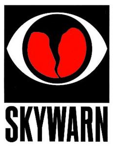
The National Weather Service confirmed nine tornadoes across Illinois on April 9, five of them in North-Central Illinois. "The strongest tornado was a long track one from near Franklin Grove (Lee County) to north of Rochelle (Ogle County) and through Fairdale (DeKalb County) and into Boone County," the NWS determined. "This has been given a preliminary rating of an EF-4 with maximum winds of 180-200 MPH. This tornado caused two fatalities and 22 injuries." The NWS said a tornado of that magnitude is "quite rare." Ciciora said all along the way, the storm was identified and tracked by numerous Amateur Radio spotters, who relayed reports to the National Weather Service through several nets. The National Weather Service credited several reports during the period of severe weather to Amateur Radio. The region also received up to golf ball-sized hail and as much as an inch and a half of rain. "I heard much of this as it happened," Ciciora added, "and it was one of our finest collective efforts." ARRL Member Input on Draft HF Band Plan Proposals Due By April 19 The deadline for ARRL members to comment on possible changes to the League's HF Band Plans, suggested by the HF Band Planning The committee developed its suggested revisions to the voluntary band plans after reviewing some 400 member comments in response to a March 2014 solicitation that sought suggestions for using the spectrum more efficiently, so that data modes may coexist compatibly. A web page is available to record members' preferences and comments. Those wishing to offer more detailed comments may e-mail ARRL. The HF Band Planning Committee will deliver its final report at the ARRL Board of Directors' July meeting. New iOS App Available for The ARRL Repeater Directory® The ARRL Repeater Directory® -- introduced this week for 2015-2016 -- has a newly launched companion app for Apple® iOS® devices. iPhone®, iPad® and iPod touch® users can download the app at no cost from Apple's App Storeâ„ , which requires a unique code found in each printed edition of the 2015-2016 directory to activate. Once activated, the app provides details for thousands of Amateur Radio repeaters found in The ARRL Repeater Directory database.
The app includes many user-defined filters, allowing users to narrow repeater results by frequency bands, or by other attributes such as "open repeaters only," repeaters with weather information, linked repeaters, and ARES/RACES repeaters. The app's database includes the current directory of frequencies included with the new 2015-2016 print editions of The ARRL Repeater Directory and in the TravelPlus for Repeaters™ software. ARRL assembles this database each year from frequency coordinators recognized by the National Frequency Coordinators Council and from carefully vetted submissions submitted by individual repeater owners. The database covers repeaters from 28 MHz to 1240 MHz, and includes ATV, D-STAR, APCO-25, Digital Mobile Radio (DMR), EchoLink, and IRLP machines.
Individuals who already have a 2014-2015 directory can use the code included with their book to activate the iOS and Android apps, as long as they have a portion of the 12 months remaining since first using the code to activate a device. Codes included with 2014-2015 edition books will expire on December 31, 2015. Codes included with the 2015-2016 books will expire December 31, 2016. ARRL produced the app with DHF Systems, LLC, the developer of ARRL's TravelPlus for Repeaters software. There are plans to introduce a pay-and-go version of The ARRL Repeater Directory iOS app in the future. ----------------- Repeater Directory® is a registered trademark of The American Radio Relay League, Inc. Apple®, iPhone®, iPad®, and iPod® are registered trademarks of Apple Inc. App Storeâ„ is a service mark of Apple Inc. iOS is a trademark or registered trademark of Cisco in the US and other countries and is used under license. TravelPlus for Repeaters is a trademark of DHF Systems, LLC. Special Event Stations to Mark World Amateur Radio Day on April 18 Saturday, April 18, is World Amateur Radio Day (WARD). The event
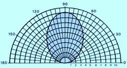
celebrates the founding of the International Amateur Radio Union (IARU) on April 18, 1925, in Paris, with ARRL Co-Founder Hiram Percy Maxim, 1AW, as its first president. From the 25 countries that formed the IARU in 1925, the IARU has grown to include 160 member-societies in three regions. Radio amateurs worldwide will take to the airwaves to mark the occasion with special event stations. A listing is on the IARU WARD page. The IARU encourages groups to promote their World Amateur Radio Day activities on social media, using the hash tag #WARD2015 on Twitter and Facebook. Ohio ARES to Sponsor "NVIS Antenna Day" Ohio Amateur Radio Emergency Service (ARES) will sponsor "NVIS Antenna Day" on Saturday, April 25. The idea, said Ohio Section Emergency Coordinator Stan Broadway, N8BHL, is to determine if the sometimes-vaunted near-vertical incidence skywave -- or NVIS -- concept really works as an antenna for emergency communication on HF. NVIS is a technique for using HF for highly reliable short-range communication.
"We are encouraging groups in every Ohio county to devise several portable NVIS antennas that they think will perform, and then actually test them on the air," Broadway said. The program grew out of an annual antenna party in Ashtabula County that has been both operating event and early spring picnic, he explained. Participants "found a vast difference in actual antenna performance, and have been able to narrow down their choices for a real emergency setup," he explained. Ashtabula County Amateur Radio Club-ARES is sponsoring NVIS Antenna Day. Ohio ARES NVIS Antenna Day will begin at 1400 UTC with operation on both 40 and 80 meters at 100 W, "as you might during a real emergency," Broadway said. "While a typical session might go through the afternoon, there is no official closing time." He pointed out that while those taking part in NVIS Antenna Day don't have to set up a completely portable or remote station, the location should offer sufficient space for several antennas and be in a fairly quiet RF environment. Suggested frequencies are 7240, 7244, 7248, and 7250 kHz, and 3850, 3870, and 3930 kHz on SSB and 3585 and 7072 for digital modes, all plus or minus existing activity. Broadway stressed that the event is not a contest but is aimed specifically at determining the best of several NVIS antenna designs through signal reports and coverage area. "A group could very well make several contacts with the same station as they try different antennas," he said. "Stations at key locations, such as the Ohio EOC, will be on the air."
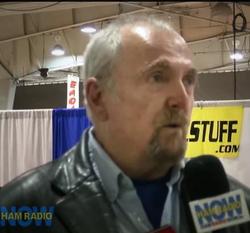
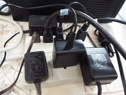
Broadway asked participating groups to list their top three antennas with descriptions and photos. "Ohio ARES will see if any particular antenna design bubbles up as the top performer across the entire state," he said. "Antenna experimentation is an integral part of the hobby, and the outcome will benefit each ARES group or club by helping to create an arsenal that can be deployed during a real emergency." As an added benefit, he noted, the event could also be a terrific opportunity to test potential Field Day antennas. NVIS Antenna Day is open to all hams, and Broadway hopes they will become interested in joining their local ARES organizations. A poster/report form is available. For more information, contact Ashtabula ARC-ARES. -- Thanks to Ohio SEC Stan Broadway, N8BHL Switching Power Supplies a More Common Noise Source than Power Lines, ARRL Lab Manager Says ARRL Laboratory Manager and EMI Expert Ed Hare, W1RFI, told the HamRadioNow webcast recently that switching-mode power supplies are a more common noise source for radio amateurs than electrical power lines. HamRadioNow host Gary Pearce, KN4AQ, interviewed Hare on April 4 at the Raleigh, North Carolina, RARSfest, where Hare also presented a forum, "Tall Tales from the ARRL Lab." Hare told Pearce that switching-mode power supplies are in -- or provide power for -- many home electronics these days.
"The old days of those iron transformers are gone," Hare said. "Every single one of these is a switcher. We're also seeing noise from pulse-width control motors." Hare said the big culprits are "little wall warts," not switching supplies designed to power Amateur Radio gear. "Every TV you own has a built-in switcher, almost every device has a wall wart, and a lot of these are imported, not necessarily meeting the FCC rules, so we're seeing more reports involving those," he said. Hare also told HamRadioNow that a few LED-type lightbulbs that are becoming more common also can be noise-generators, as are "grow lights" used for cultivating plants indoors. He said that the ARRL Lab can work with manufacturers to correct these problems, but the Lab needs model numbers and "specific information about the problems amateurs are having, so that we can put some of our resources toward helping."
Many interference issues can be resolved without FCC intervention, Hare said, noting that Commission enforcement is the last step, if other efforts fail. "We've been told by Laura Smith [of the FCC Enforcement Bureau] that she's going to continue to be engaged in this," he said, "so we're going to continue to send problems [in] that direction." Hams experiencing RF interference problems can contact the ARRL Laboratory by contacting Ed Hare or ARRL Lab EMC Specialist Mike Gruber, W1MG. The complete interview with Hare is in Episode 196 at www.hamradionow.tv. -- Thanks to Gary Pearce, KN4AQ/HamRadioNow 2015 ARRL/TAPR Digital Communications Conference Issues Call for Papers
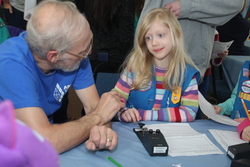
The submission deadline is August 17. E-mail submissions to Maty Weinberg, KB1EIB, at ARRL Headquarters. Do not attach ZIP files, as these will be rejected by the ARRL e-mail server. For more information, visit the DCC website or call TAPR at 972-671-8277. "Thinking Day" Activity Gets Girl Scouts Thinking About Ham Radio When Girl Scout leader Jill Galus, KB1SWV, was planning a "Thinking Day" activity last fall, she learned about Thinking Day On The Air (TDOTA). The World Association of Girl Scouts and Girl Guides designates February 22 as Thinking Day -- to commemorate the birth of both Scouting founder Lord Robert Baden-Powell and his wife
Olave, the first Chief Guide. On Thinking Day, Girl Scouts and Guides to reflect upon the international nature of their movement. Akin to the Boy Scouts Jamboree on the Air (JOTA), Thinking Day on the Air is a global activity aimed at encouraging Girl Scouts and Guides to make friends via Amateur Radio. Both events were conceived by Les Mitchell, G3BHK (SK). Galus asked her dad, Skip Youngberg, K1NKR, if he and his club, the Nashoba Valley Amateur Radio Club, would be willing to support a TDOTA station this year for her troop in Raymond, New Hampshire. The Nashoba Valley Amateur Radio Club (NVARC) supported Galus -- "and had a lot of fun doing it," Youngberg told ARRL. The club agreed to let the girls use the club's N1NC call sign and its tower trailer, while Youngberg offered equipment. "By the time Thinking Day arrived on February 21, five local other troops had joined hers for the event," Youngberg said. Stan Pozerski, KD1LE; Ralph Swick, KD1SM; Greg Cote, KB1WAQ, and his daughter Sarah, also a Girl Scout, and Youngberg traveled to New Hampshire and set up at a Masonic lodge. In addition to radios for HF and VHF, the NVARC team set up code practice oscillators for the girls to try. Eighty girls had signed up, split between morning and afternoon sessions, but because bad weather was forecast for later that day, all but 13 of them arrived in the morning. "Needless to say, there was a lot of 'audio QRM,'" Youngberg said. "Nevertheless, every activity succeeded in capturing the girls' interest."
The ham radio mentors demonstrated Morse code and taught the youngsters how to send their names on the code practice oscillators. Galus had maps and a globe on hand to teach world time concepts, as well as a crafts table to string beads to spell "GS" in Morse code, as a keepsake. The girls did not succeed in making contact with other Girl Scouts or Girl Guide groups, but the hams were able to demonstrate how to get on the air, both on HF and VHF. Afterward, Youngberg and his daughter sent QSL cards to the stations they'd worked. "When the replies come back," he said, "those budding scientists and potential new hobbyists will be reminded of a great experience and will have another thing to be excited about." More details and photos are available in the March edition of the NVARC Signal newsletter. -- Thanks to Skip Youngberg, K1NKR, and Jill Galus, KB1SWV "Radio DARC" Program Debuts on Ham-Operated German Shortwave Outlet The inaugural transmission of the "Radio DARC" Amateur Radio program aired over the March 21-22 weekend via Channel 292 at 6070 kHz. The German-language program was produced in cooperation with Germany's national Amateur Radio society -- the Deutscher Amateur Radio Club (DARC). A group of amateurs in Germany obtained a license to broadcast on the 49 meter shortwave broadcast channel after German national broadcaster the Deutsche Welle closed down a 500 kW shortwave broadcast transmitter near Munich. Using parts scavenged from the Deutsche Welle site, the ham group built up a 10 kW transmitter.
"The response was overwhelming," said Rainer Englert, DF2NU. "Our dreams were exceeded many times over. The team got over 1500 reception reports from 11 European countries." These even included S-9 reports from Russia and Iceland. Englert said the station puts in a signal that's often 60 dB over S-9 within Germany, adding that it will take weeks to answer all QSL requests and comments. The station has been heard in North America, but it has competition on 6070 kHz. Hosting "Radio DARC" is Conny Ferrin, a former Radio Luxembourg air personality. In the 1970s, Radio Luxembourg deployed a 2 GW medium-wave transmitter on 1440 kHz and a 500 kW shortwave Amateur Radio Organizations Join Forces to Mark Gallipoli Battle Anniversary The Wireless Institute of Australia (WIA), the New Zealand Association of Radio Transmitters (NZART), and the Telsiz ve Radyo Amatörleri Cemiyeti (TRAC) in Turkey have joined forces to mark the centenary of the World War I Battle at Gallipoli.
ANZAC Day commemorates all servicemen and women. Many radio amateurs played a key role in wartime communications, and a range of events will include the use of commemorative call signs, some with ANZAC suffixes. In Turkey, at least two commemorative call signs are on the air -- TC100GLB and TC100GP. In Australia, eight ANZAC-suffix call signs, one from each state or territory and the national capital of Canberra, will be on the air on April 25. Australian radio amateurs may use the prefix AX on April 25-26. The VK9NT Norfolk Island DXpedition will identify as AX9NT on ANZAC Day, April 25. In New Zealand, NZART will operate ZL100ANZAC through the month of April. -- Thanks to Jim Linton, VK3PC In Brief...
The K7RA Solar Update Tad Cook, K7RA, Seattle, reports: Solar activity increased this week. Average daily sunspot numbers increased from 50.1 in the April 2-8 forecast week to 65.6 in the just-ended April 9-15 forecast period. Average daily solar flux rose from 118.4 to 132.5. Geomagnetic indexes also increased.
Predicted planetary A index is 15 on April 16, 8 on April 17-20, 5 on April 21-22, 8 on April 23-24, 10 on April 25, 8 on April 26-28, then 12, 18, and 12 on April 29 through May 1, 8 on May 2-9, 5 on May 10-12, then 15, 20, and 12 on May 13-15, and 8 on May 16-21. You can download and examine my archive of these forecasts, updated daily, for flux values and Ap index (click the "Download this File" button; files are Excel spreadsheets). This weekly "Solar Update" in The ARRL Letter is a preview of the "Propagation Bulletin" issued each Friday. The latest bulletin and an archive of past propagation bulletins is on the ARRL website. Look for reports from readers in Friday's bulletin. Send me your reports and observations. -- Tad Cook, K7RA Just Ahead in Radiosport
See the ARRL Contest Calendar for more information. Upcoming ARRL Section, State, and Division Conventions and Events
Find conventions and hamfests in your area.
. . .
Subscribe to...
Free of charge to ARRL members...
| ||||||||||
The ARRL Letter is published Thursdays, 48 times each year. ARRL members may subscribe at no cost or unsubscribe by editing their Member Data Page as described at http://www.arrl.org/arrlletter/. Copyright © 2015 American Radio Relay League, Inc. All Rights Reserved  | ||||||||||
 "We have had a good initial response from our members in support of our grassroots efforts, but we have a long way to go," Henderson said. "Our Washington team has met with dozens of members of Congress and congressional staffers over the past month."
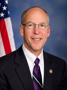
 "The storms that affected North-Central Illinois yesterday were unheard of for our area," said ARRL Illinois Section Manager Tom Ciciora, KA9QPN, noting that the stricken communities are just north of where he lives. "At least one small community was completely leveled, and damage exists from Ogle County northwest into Lake County."
 Committee, is April 19. The survey is part of the committee's efforts to adjust the band plans for the RTTY/data/CW portions of 80 through 10 meters -- excepting 60 meters.
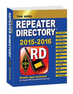 "Use the app to quickly locate nearby repeaters based on your current location, or search the entire directory by city/state or coordinates," said ARRL Marketing Manager Bob Inderbitzen, NQ1R. "The app also places nearby repeaters on integrated terrain-viewing maps. Touch a repeater and view detailed information including output and input frequency, and other operating notes. Users of the Android app, introduced a year ago, will find the new iOS version familiar."
 The activation code permits single users to activate the app for 12 months. The 2015-2016 ARRL Repeater Directory is available now from
 The ARRL and TAPR are soliciting technical papers for presentation at the 34th Annual ARRL/TAPR Digital Communications Conference (
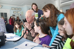
.jpg)
.gif) transmitter on 6095 kHz, airing a popular music program in the days before commercial broadcasting licenses were available on the Continent. Replete with jingles and music bumpers, "Radio DARC" includes music that was popular in the 1960s and 1970s, interspersed with news and commentary of interest to radio amateurs and SWLs. As Englert explained in an editorial commentary during the initial broadcast, they want the program to be "at once nostalgic and modern." Read
transmitter on 6095 kHz, airing a popular music program in the days before commercial broadcasting licenses were available on the Continent. Replete with jingles and music bumpers, "Radio DARC" includes music that was popular in the 1960s and 1970s, interspersed with news and commentary of interest to radio amateurs and SWLs. As Englert explained in an editorial commentary during the initial broadcast, they want the program to be "at once nostalgic and modern." Read  Around the world, there will be other related activity, with a major focus beginning on ANZAC Day, April 25. That's when the three IARU member-societies will commemorate the event involving the original Australian and New Zealand Army Corp (ANZAC) and Ottoman Empire soldiers who did battle at Gallipoli in Turkey.
 GAREC 2015 Cancelled: Sponsors of the 2015 Global Amateur Radio Emergency Conference have announced they are cancelling the event due to a lack of interest. Seppo Sisatto, OH1VR, said GAREC 2015 registrations were too few, and the decision was largely financial. GAREC 2015 was set to mark its 10th anniversary this June in Tampere, Finland, where the first GAREC was held.
.jpg) Special Event Stations to Commemorate ITU's 150th Anniversary: Special event stations AT150ITU and
Special Event Stations to Commemorate ITU's 150th Anniversary: Special event stations AT150ITU and  Bruce Draper, AA5B, Taking "Contest Corral" Reins: Beginning with the June QST, a new trail boss will manage "Contest Corral," as well-known contester Bruce Draper, AA5B, takes the reins. Draper will collect contest calendar listings directly from the online
  Matt Ettus, N2MJI, Wins Wireless Innovation Forum International Achievement Award: ARRL member Matt Ettus, N2MJI, of Mountain View, California, is the recipient of the annual Wireless Innovation Forum International Achievement Award. Award winners were announced on March 26 at the Wireless Innovation Forum Conference on Communications Technologies and Software Defined Radio (
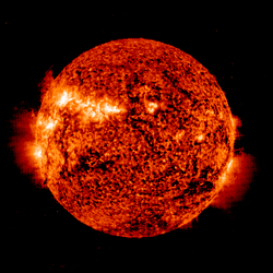 The latest prediction shows solar flux at 160 on April 16-17, 165 on April 18-22, 155, and 135 on April 23-24, 115 on April 25-26, then 120, 125, and 130 on April 27-29, 125 on April 30 through May 5, 130 on May 6, 135 on May 7-11, and 130 on May 12-14.